

Finding an REV Wind Park
Locating Long-gone 1980s Palm Springs Wind Parks - Installment 1.

As Director of Education for Palm Springs Windmill Tours, I constantly expand my knowledge to benefit our visitors. Granted, most guests aren’t interested in the depth I’m developing, but you never know when some piece of trivia triggers new knowledge or solves an unsolved puzzle. I’ve now experienced that dozens of times.
I’m attempting to match photographs of area wind parks installed in the 1980s with what I see today. Knowing which machines stood where and who operated them helps build the history of the San Gorgonio Pass wind farm. Matching the location of the old photos precisely enough also allows me to compare and contrast them with the present. Without concerted effort, much of the early history of these wind farms will be lost since many early developers and operators are now in their eighties.
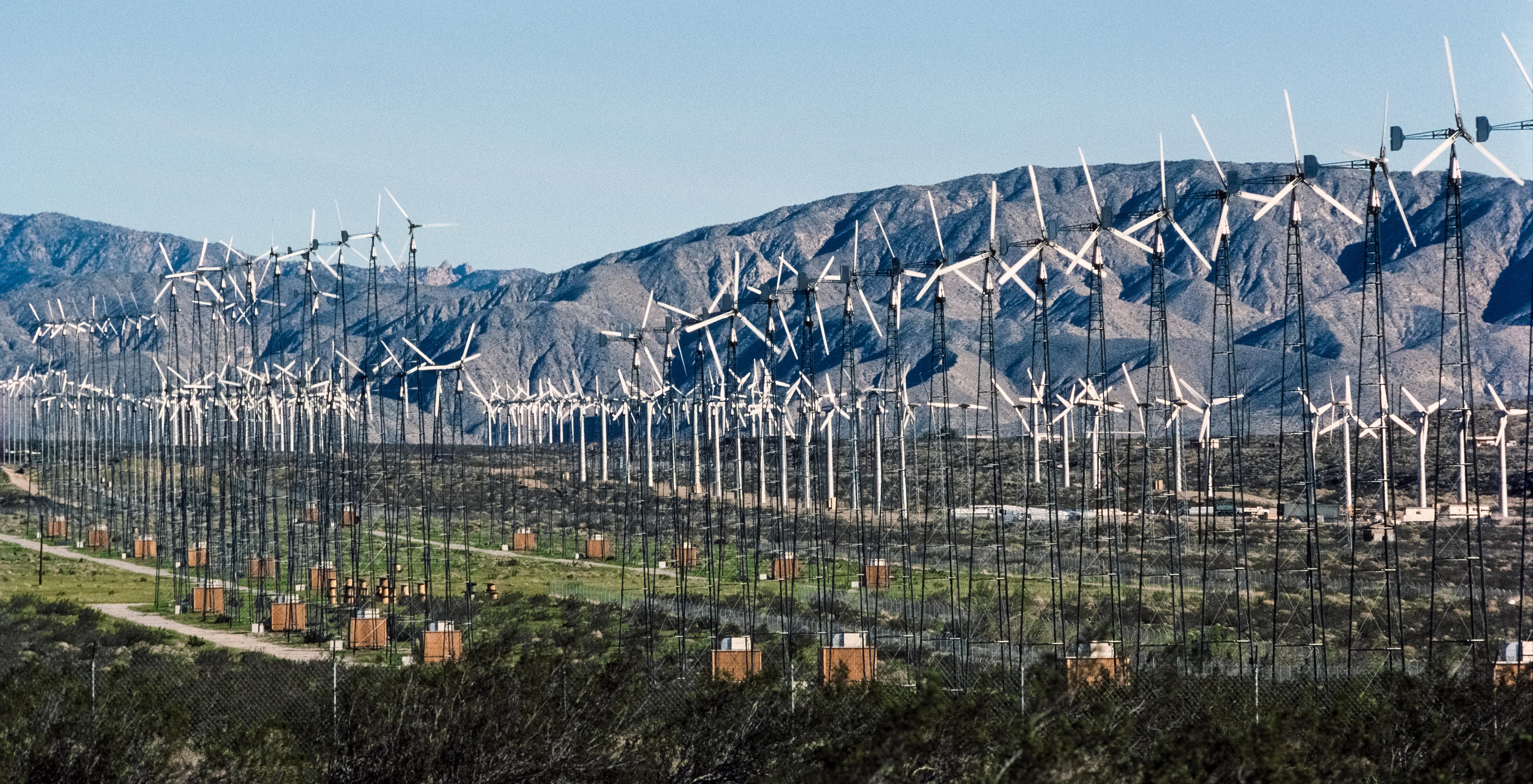
The historical photo below shows many Jacobs wind turbines. They were unusual in many ways, including their prominent tail vane that kept the wood-blade rotor facing into the wind without gears, motors, and computer controllers. They stood on 80-foot towers (some on 120-foot towers) and, evident from the photo, were closely spaced due to the small rotor size. More than 600 of the turbines were installed by Renewable Energy Ventures (REV). Unfortunately, the Jacobs turbines did not perform well, and the wind parks were repowered early in the history of the San Gorgonio wind farm.
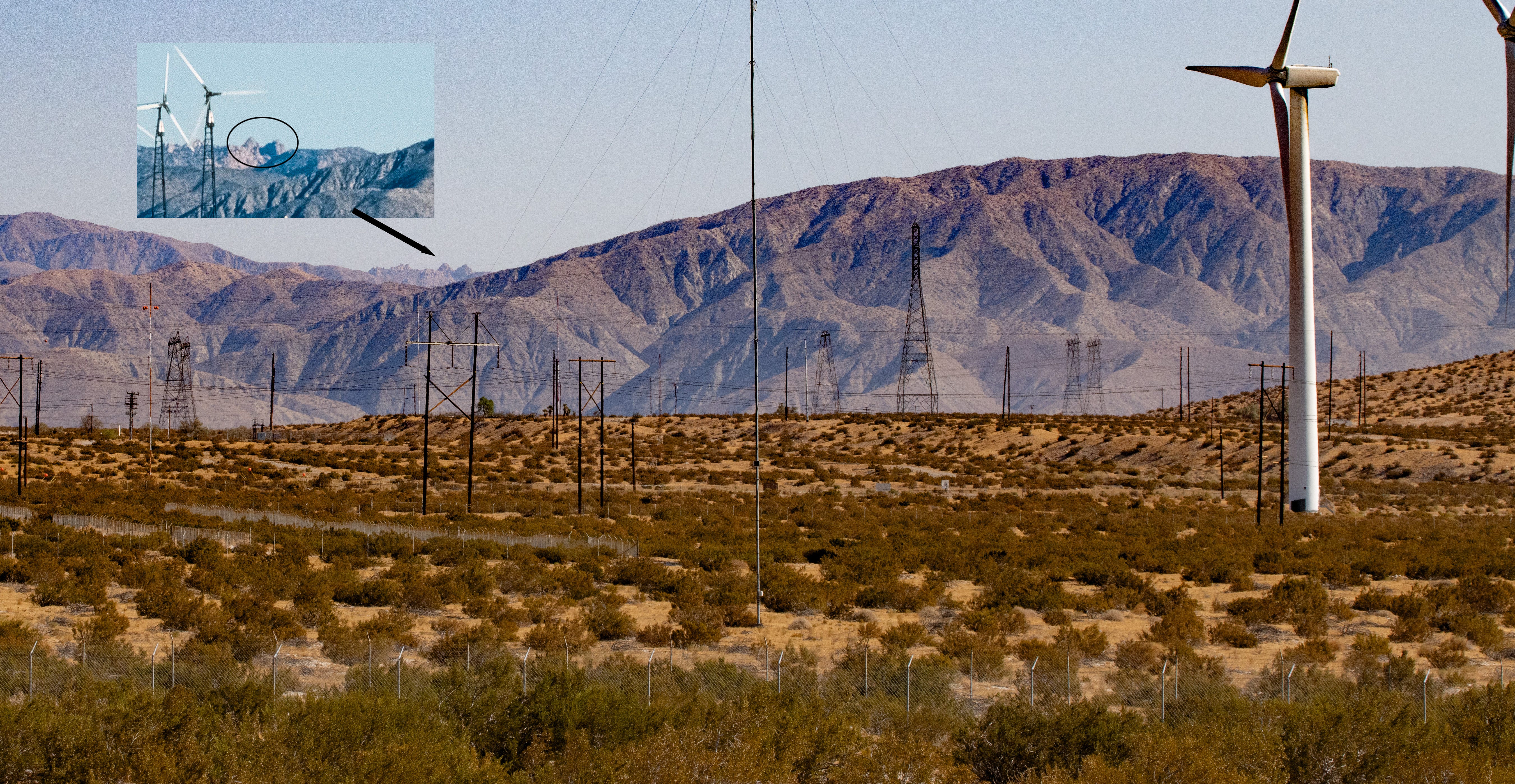
The shape of the hill significantly helped me in the background. This hill (a western part of the Little San Bernadino Mountains) is visible north of Palm Springs Windmill Tours. From that location, however, we can’t see the two peaks far in the distance to the left where the hill slopes down. Google Street View helped find them just a few hundred feet west along 20th Avenue. Below is my photo from that location, along with an inset showing the two peaks from the above image that came into view.
Unfortunately, I failed to recognize that I almost had a shot that matched that first photo. My attention focused on the background behind the Jacobs wind turbines, whose closely spaced towers made it challenging to see the machines and electrical towers behind them. More confusing were the Carter 25 wind turbines visible at the far left of the historical image because I knew where they stood. Matching that part of the photo meant moving closer (or so I thought), so I headed off on a desert hike of about 45 minutes round trip in 100F temperatures and lots of sun.
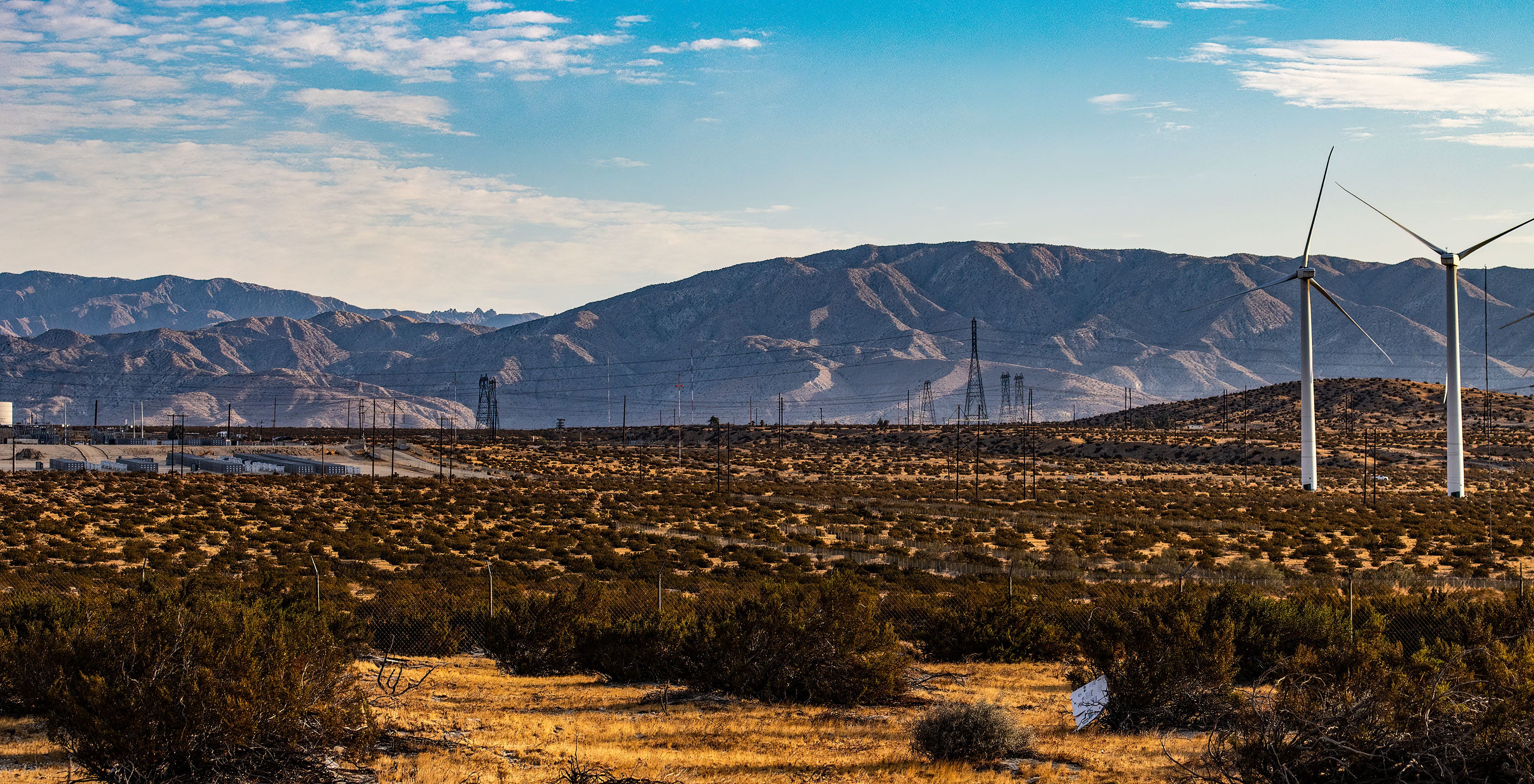
After reviewing my new images, I roughly matched the background mountains but was struck by the size of the utility poles in the foreground. This photo could not have been taken at this range. I also wondered how the photographer had gained about 40 feet of altitude.
The bottom line is that my original photo was very close to the matching location—I was just fifty to one hundred feet too far east. I also should have accounted for the machines of the day standing close to fence lines. Most photographers would not have taken a photo from the fence line as I had. They would have stayed away for perspective and remained closer to the main road, 20th Avenue.
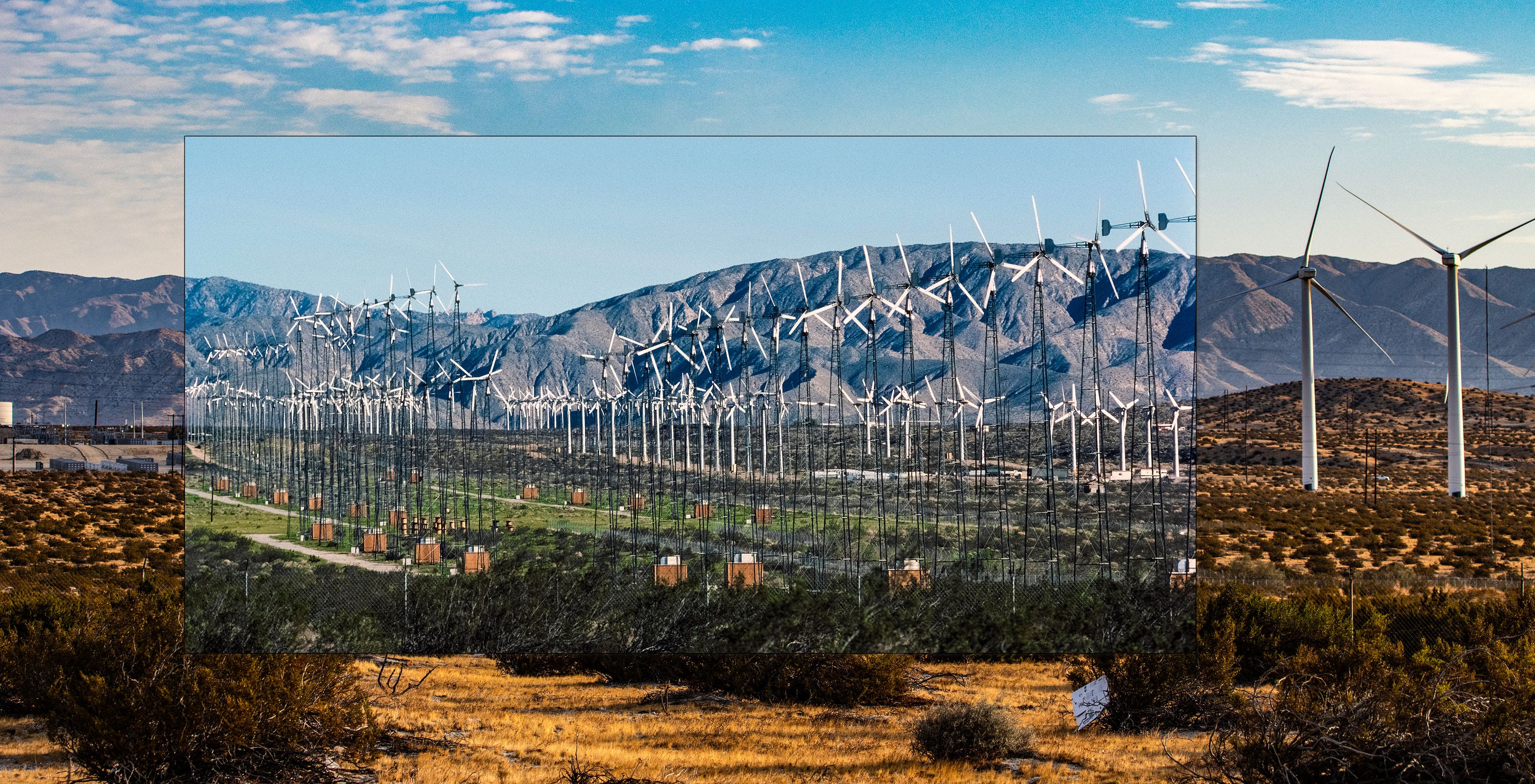
The correct photo also solved the mystery of how the Carter turbines appeared in the historical photo. Several rows are visible at the left edge. Batteries now sit where those Carter machines once operated. I used Melissa Lane as a marker to line up my first photo, but Melissa Lane wasn’t there when the historical photo was taken. It makes much more sense now. Dillon Road is not directly visible but runs horizontally across this image just in front of the Carter turbines and the three-blade Danish turbines near the middle and far right.
Which REV WInd Park?
REV developed three wind parks by 1986. I don’t yet know where each was located.
Whitewater/Riverview installed 218 Jacobs turbines along with 63 Nordtanks. It was transferred to Wintec Energy in 1987. The absence of Nordtank turbines in the photo (and also absent in another photo overlooking the area from the east) suggests this photo is not the Whitewater/Riverview Wind Park. I suspect the wind park was north of Zond’s Painted Hills installation, but I could use help locating it.
REV Wind Power Partners featured 168 ESI turbines and 208 Jacobs. While I see some ESI turbines through the Jacobs towers, there aren’t enough. Another historical photo shows a much larger cluster of ESI machines to the west and somewhat north. It’s possible REV Wind Power Partners used multiple parcels based on who would lease to them.
In mid-1985, the Jacoby-Kerr Wind Park placed 204 Jacobs turbines. Interestingly, 16 stood on 120-foot towers, 50% taller than the others. Look at the original historical photo. I’ve convinced myself I see a few Jacobs turbines on towers taller than the others, but I count 18 or 22.
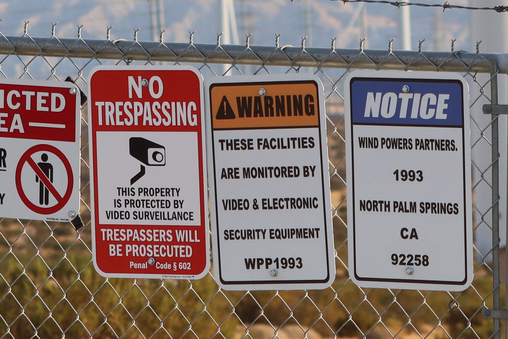
I know the location of my photo was repowered with Kenetech KVS-33 turbines in 1994 and that Kenetech/US Windpower bought the REV Wind Power Partners project in 1993. I presume the location of the historical photo is the REV Wind Power Partners project, and the separately located ESI turbines to the northwest were considered part of it, along with the dozens apparent through careful examination of the original image. Perhaps telling, Kenetech/US Windpower named their repower project Wind Power Partners 1993. The rather obvious hint is posted on the fence along 20th Ave.
Of course, I welcome clarification from competent sources.
Thanks and kind regards.